
Hurricane Melissa a warning sign of ‘warmer seas fueling stronger storms’: Experts
Following Hurricane Melissa’s devastation, climate experts warn that warming oceans mean a future of more powerful and more punishing storms- ‘Storms of this intensity have happened before, and climate change will continue producing these sorts of large storms,’ says James Baldini, professor of earth sciences at the University of Durham- Large-scale currents ‘have weakened over the last 20 years and are predicted to weaken further in decades to come … favoring strong hurricanes,’ says Robert Marsh, professo
By Rabia Ali
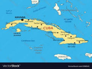
ISTANBUL (AA) – Hurricane Melissa has left a trail of destruction across the Caribbean – and a warning for the world. As emergency teams in Haiti, Jamaica, and Cuba clear wreckage from one of the most powerful storms ever recorded in the region, climate scientists are sounding the alarm: the Atlantic’s warming waters are fueling stronger, slower, and deadlier hurricanes.
“Once heated at large scale and to depth, the oceans are slow to cool down again; that heat is now in place for years to come, and it just takes the ‘right’ atmospheric conditions for hurricanes to spin up,” said Robert Marsh, professor of oceanography and climate at the University of Southampton.
Hurricane Melissa – the third Category 5 storm of 2025 and the most powerful ever to hit Jamaica – devastated communities across the Caribbean. In Cuba, the UN estimates that 2.2 million people were affected, with damage reported to some 60,000 homes, 461 health centers, and 1,552 schools. Across Haiti and Jamaica, local media say flooding and landslides killed at least 75 people.
“Melissa was the strongest hurricane to make landfall on Jamaica, surpassing Hurricane Gilbert in 1988,” said James Baldini, professor of earth sciences at the University of Durham. “It was also the third most intense tropical cyclone in the Atlantic Basin, and the most intense to make landfall.”
Melissa’s maximum sustained winds reached 185 miles per hour (mph), with a minimum central pressure of 892 millibars (mbar) – tying it for the third-most intense Atlantic hurricane on record. What made it particularly dangerous, Baldini said, was how quickly it intensified, increasing by about 70 mph in 24 hours.
Marsh added that the storm’s landfall winds matched century-old records. “As a landfalling Category 5 hurricane, Melissa was close to unprecedented for the region as a whole over recorded history – one of the top three for landfalling winds over the last century, and unprecedented for Jamaica.”
- Slow-moving destruction
What distinguished Melissa, experts say, was not only its power but its pace. The hurricane lingered over land for days, magnifying the devastation.
“It often appeared to simply stall, and other times moved along at human walking speeds – about 2 miles per hour,” Baldini explained. “Typical hurricanes move at 10-20 mph in the Caribbean. The combination of this slow movement, strong winds, and heavy rainfall is what made the storm so catastrophic … The longer a hurricane remains over a location, the more flooding there is, and the more opportunity for wind-related impacts.”
Marsh described the storm as “unusually sluggish,” comparing it to Hurricane Dorian, which devastated the Bahamas in 2019. “Over very warm water, slower-moving hurricanes have longer to grow stronger,” he said.
Melissa’s northward track, rather than the more typical westward path, prolonged exposure across densely populated islands already struggling with fragile infrastructure.
- The climate connection
Both scientists agreed that rising ocean temperatures are turbocharging storms like Melissa. “The evidence is that hurricanes are intensifying with climate change, specifically gaining more power from ocean warming both at the surface and to greater depth, notably in the southern Caribbean,” Marsh said.
His recently published paper says that over the past two years, the tropical North Atlantic experienced unusually warm ocean temperatures, leading to hurricanes in 2024 becoming stronger before making landfall.
Another 2024 anomaly was that ocean currents moved the very warmest water from the eastern to western tropical regions.
“The combination of heat exchange from the air into the sea, along with ocean currents, led to the record-breaking temperatures of consequence for hurricanes,” the study said.
Warm sea surfaces, Baldini added, are the ultimate fuel source for tropical cyclones.
“Water temperature has to be about 27 degrees Celsius (80.6 degrees Fahrenheit), but the warmer the water is, the more powerful the hurricanes,” he explained.
He cited findings from the Imperial College Storm Model (IRIS), which estimated that climate change increased Melissa’s rainfall by 16% and its maximum wind speed by 7%.
“The current thinking is that hurricanes will get more powerful in the future due to climate change, but not necessarily become more frequent,” he said.
- A warming ocean, a rising threat
Looking ahead, scientists warn that even if the Atlantic remains calm through the winter, the next hurricane season could bring equally destructive storms.
For the next season, a further problem is the weakening of the large-scale currents – primarily the Gulf Stream – that carry heat away from the tropics, Marsh explained.
“These currents have weakened over the last 20 years and are predicted to weaken further in decades to come. If less heat is carried poleward, more heat stays in the region, helping the tropical Atlantic to warm even more – favoring strong hurricanes.”
Baldini said such events are likely to become the new normal. “Storms of this intensity have happened before,” he said, “and climate change will continue producing these sorts of large storms.”
Kaynak:![]()
This news has been read 207 times in total


Türkçe karakter kullanılmayan ve büyük harflerle yazılmış yorumlar onaylanmamaktadır.